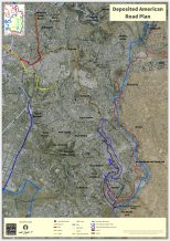
The American Road, East Jerusalem

The American Road was planned and underwent its first steps of implementation in the mid-1960s by an American company that was hired by the Jordanian government–that’s where it gets its name. The objective of the road was to connect the villages southeast of Jerusalem on the outskirts of Wadi an-Nar (Nachal Kadron), providing an alternate traffic route to Hebron Road, which was on the Israeli side of the border. At the outbreak of the 1967 War, construction of the American Road was halted: the southern section of the highway was already ready to be paved–and was indeed later paved by the Israeli Jerusalem Municipality–while the northern section was only in the earliest stages of work. To this day, it remains unfinished.
As part of Plan 2683A for the neighborhood As-Swahra, which was drafted in the mid-1990s (and published in 1996), the American Road received for the first time regularized legal status as a scenic route, planned to be 30-meters wide. The vast majority of the area on either side of the highway remained zoned for open space, with the exception of a residential area to the east of Konber and a number of residential areas west of the road with rural building rights. Starting in the mid-2000s, prior to the approval of the Jerusalem Outline Plan 2000, it became known that the road was set to transform into an urban road. In spite of this, residents that requested to move forward with private plans along the highway were continuously rejected on the grounds that the official new policy had not yet been set. In June 2019, a detailed outline plan for a plan called the “Urban Development Along the American Road” (number 101-0379594) was published detailing the new policy, which had laid out generally several years prior in the As-Swahra Master Plan.
This change–from a rural road to an urban road–is significant. The new policy permits massive construction of buildings up to eight stories high on either side of the road, for the combined use of commercial, business, hotels, and residential buildings. That being said, the building plan in its current form is extremely problematic. While there is an urgent need for residential building and minimal demand for office spaces, the plan proposes building 65% business centers, 25% commercial space, and only 20% residential space, reserved exclusively for the highest floors. In addition, there is a concern that, short of entirely re-thinking the proposed implementation stages of this plan, almost no part of this plan could be realized in practice. The plan is effectively a raze-and-rebuild plan, without including the required incentives and/or alternative options in coordination with the reality on the ground. These problems and more, including recommendations for improvement, can be read in further depth in the objection presented by Bimkom in partnership with concerned residents (in Hebrew, September 2019). Map
