|
|||
|
The Bedouin Communities East of Jerusalem – A Planning Survey |
|||
|
●
Introduction Khan Al-Ahmar Communities ● Summary
|
2. Al-Muntar Community: Jahalin Tribe – the Hathalin family Population: 35 families, approx. 350 residences
Water: Independent hookup from As-Sawahra; Electricity: none Sewage: none Education: Elementary school in Wadi Abu Hindi; high school in As-Sawahra Medical services: Mobile infirmary, twice a month Daily needs: As-Sawahra Religious building: none Cemetery: Nabi Musa and Al-E’izariya Flocks: approximately 5,000 heads of livestock
|
||
Identity Card 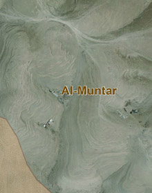 |
Chronoligical Development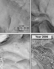
|
Planning Survey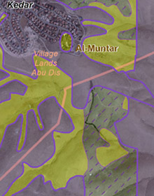 |
|
|
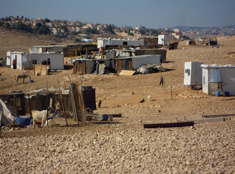
The community is located near Mt. Muntar, east and southeast of the Qedar settlement. The residents arrived there in 1948, after being evacuated from the Tel Arad area. The area was selected due to its physical advantages, since it is relatively high and open. The community is somewhat scattered due to the many flocks, and the need to ensure sufficient distances between the families in order to afford sufficient space for each family to graze its holdings. When they first arrived in the area, the residents made agreements with residents of As-Sawahra to settle on their privately owned lands. According to the current residents, the original owners have long relinquished their land rights on behalf of the Bedouin. In the view of the authorities, all of the lands in the area are declared state lands. Most of the area is located within a closed military zone, under an order issued at the beginning of the 1980s that was recently renewed in 2007. An historic investigation into the settlement pattern there reveals that over the years, the Bedouin have been moving eastward, from the vicinity of the Qedar settlement, to its present concentration near the eastern foot of Mt. Muntar. From 1995-1997, demolition orders were issued for structures there and government authorities demolished every home in the locality, destroyed the property and confiscated the flocks. And yet, the community was re-established. In 2005, a seizure order was issued for the lands along the separation barrier that passes through the locality, but the barrier’s course was altered and the seizure order was cancelled in 2006. This notwithstanding, a seizure order for the lands on the planned course of the “Mirkam Hayyim” road, which passes to the east of the loc.0 ality, was issued in 2007 and remains in effect. In 2011, demolition orders were again issued for all of the buildings in the locality, including ten caravans supplied to the residents by human rights organizations as a replacement for their tin houses.
This community owns a relatively large number of flocks. Each family has a flock averaging some 140 specimens, and a number of families have flocks numbering 300-500. During the summer, grazing takes place near the area of residence, and in the winter, all of the flocks migrate approximately 5 kilometers to the east to a richer grazing area. The flocks serve for the manufacture of products used domestically, and sometimes, during certain periods, are also sold and marketed, in keeping with the demand. In the area of the northern cluster, there is a plot of land for non-irrigated crops in winter, wheat for flour, and barley. The elementary school children, some 50 students from all of the Al-Muntar clusters, walk daily over a distance of 1-2.5 kilometers each direction, to and from the elementary school in Wadi Abu Hindi. The few who continue to the higher grades attend the high school in As-Sawahra; very few continue to post-high school educational frameworks. Residents complain of the odors that reach them from the waste burial site, and claim that the fumes cause a high rate of asthma, mainly among the children. This problem becomes even more acute due to the lack of medications, which is so extreme that some medications prescribed at a dose of twice daily are administered only once a week. In addition, the sewage from the settlement of Qedar flows towards the Bedouin locality, and in the summer causes putrid odors and mosquito infestations. Main planning constraints: – State lands declared lacking an agreed upon arrangement regarding ownership and usage rights – Closed military zone order – Seizure orders for the establishment of the “Mirkam Hayyim” Road – Limitations on grazing lands and access to water sources |
|||