|
||
|
The Bedouin Communities East of Jerusalem – A Planning Survey |
||
|
●
Introduction Khan Al-Ahmar Communities ● Summary
|
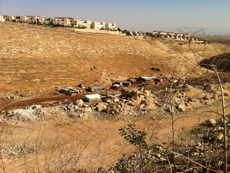
6. Wadi Al 'Awaj Community: Jahalin Tribe –Salamat, Kurshan and Hammadin families Population: 70 families, approx. 500 residents Water: Independent hookup from Al-Jabal Electricity: Independent hookup from Al-E’izariya Sewage: none Education: Elementary school in Al-Jabal; high school in Al-E’izariya Medical services: Infirmary in Al-E’izariya Daily necessities: Al-E’izariya Religious building: none Cemetery: Al-E’izariya Flocks: approximately 7,000 heads of livestock
|
|
Identity Card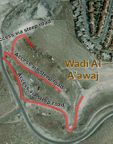 |
Planning Survey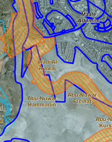 |
|
|
The community resides south of Ma’ale Adumim, to the
east and west of the road to Qedar. This community also originally came
from the Tel Arad area in the Negev, and settled in the early 1950s in
the area known as Um Rassas, where Ma’ale Adumim is located today. Since
the 1970s, as Ma’ale Adumim gradually expanded, residents were repeatedly
evacuated with each stage of the city’s development. Every new
neighborhood built or each new street paved in the settlement pushed the
Bedouin residents outside the city limits, until they reached their
present location. Historical analysis indeed shows that the area was
originally populated at the end of the 1980s, and grew significantly in
the mid-1990s and in the first years of the new millennium. The Bedouin
first took up residence on private lands belonging to Abu Dis, but most of
the lands today are lands that the state views as suitable for declaration
as state lands; the status of ownership has yet to be determined. Most of
the locality is within the Ma’ale Adumim jurisdictional area. Some of it
falls within the limits of the city plan, and some is in the E1
boundaries, while the clusters in the northern part of the locality are
within the planning area for a new road, in territory expropriated for
this purpose in 2002. The planned course for the separation barrier passes
near the locality, to the west, and in 2005, seizure orders were issued in
preparation for its establishment there. Demolition orders for most of the
homes west of the road were issued in 1997-1998, and again in 2005. Until
today, no houses in the area were actually demolished, but a complete
prohibition was issued against adding on, modifying or repairing to
existing houses. Since the establishment of Ma’ale Adumim, approximately ten wells that provided for the area of Um Rassas can no longer be used, and all cultivation of agricultural land has been prohibited. The extent of grazing lands has been drastically reduced, and today, flocks graze only in the limited area of the immediate vicinity; in the spring, shepherds migrate with them to the area of Wadi Saa’b, located east of the residential area. The flocks serve for the manufacture of milk products, both for domestic use and for trade, when possible, mainly to families in Abu Dis; distribution to market is carried out on public transportation. Residents earn their living almost exclusively from raising flocks, and since the flocks have been greatly reduced over the years, rates of employment and non-participation in the family livelihood are very high. Main planning constraints: – Located within the development and expansion plans for Ma’ale Adumim and E1 – Includes state lands declared without an accepted arrangement regarding ownership and rights of usage – Course of the separation barrier – Included partially within the plan for a local road – Limitations on grazing lands and access to water sources |
||